Does Croatia have any mountains?
There are many mountains in Croatia. Lika and Gorski Kotar are the areas in the Dinarides with the greatest concentration of relatively high elevations. 25.61 percent of Croatia's territory is above sea level at an elevation of 200 to 500 meters. 17,11% of the country lies between 500 and 1,000 meters above sea level.
3.71 percent of the land is 1,000 to 1,500 meters above sea level.
1.5% of Croatia's territory is higher than 1,500 meters (4,900 feet) above sea level.
Croatian mountainous areas can be divided into two parts:
- Pannonian plain mountains
- Dinarides karst mountains
Pannonian plain mountains
Croatian Pannonian mountains are not as high nor rocky as karst mountains. These low mountains are isolated and scattered between the Sava and the Drava rivers, from Slavonia to Zagorje. The lowest mountain is Bilogora at 309 meters, and the highest is Ivanščica at 1061 meters. These Pannonian mountains reach no higher than 1000 meters, yet they rise majestically from the plains like islands from the sea. The Slavonian mountains Krndija, Dilj, Psunj, and Papuk, which surround the Požega Valley, rise as the most striking of them all.
The orogeny of these mountains took place in the Paleozoic, making them considerably older than the rest of the Croatian mountains. About 600,000 years ago, these mountains were islands of the ancient Pannonian Sea.
Dinarides karst mountains
There is also the Dinarides, a younger carbonate chain formed by the rising seafloor caused by Africa's tectonic plate pushing on the European plate. Dinarides are a united tectonic unit developed during Tertiary thrusting. The karst Dinaric Mountains with the Shar-Pind Mountains in the southeast and the South Limestone Alps in the northwest form a tectonic unit that covers western Balkan peninsula; hence these three orogenic parts as a whole are called the Dinarides.
Are there Alps in Croatia?
Yes, Croatia has Dinaric Alps (Dinaric Mountains), a mountain system named after Mount Dinara. It covers most of the mountainous areas of west Balkan, including Croatia, Bosnia and Herzegovina, Serbia and Montenegro, and Slovenia and Macedonia. It is estimated that Dinaric Alps are around 650-700 km long and 50-200 km wide.
The extended borders of the Dinaric Alps stretch from the edge of the Friuli lowlands in Italy through the northwestern hills of Slovenia and Ljubljana marshes, then along Temnica and Krka to the Sava in the Krško field and the Sava river to the east.
In the east, the border of the Dinaric Mountains stretches along the Kolubara river in Serbia, the western foot of Rudnik and the Ibar valley to Kosovo Polje, and in the southeast from Kosovo Polje through Metohija and Drim to the Skadar Valley.
The direction of mountain ranges from the northwest to the southeast (Dinaric direction) is the main characteristic of the entire Dinaric Alps.
The Dinaric Alps consist of a limestone area in the southwest, dominated by karst, and areas in the northeast with covered karst (dense river network). Karst is mostly developed in the coastal belt of the Dinaric Alps.
The highest parts of the Dinaric Alps (up to 2694 m in Prokletije) stretch parallel to the Adriatic Sea from northwest to southeast. It is mostly covered with forests and lush pastures. The belt of high mountains of the Dinaric Mountains is difficult to access.
What major mountains are in Croatia?
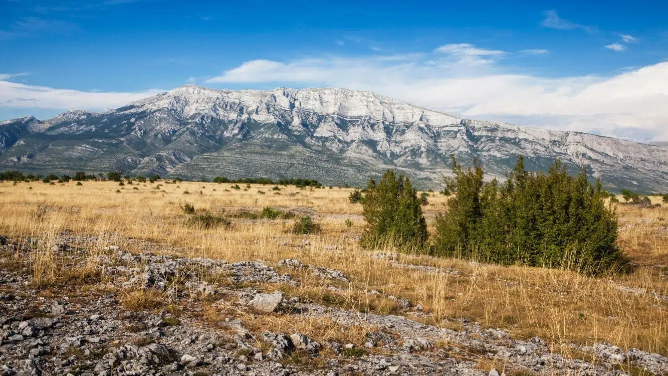
Dinara Mountain
Dinara is a mountain massif on the border of Dalmatia (Croatia) and Bosnia and Herzegovina (BiH).
It stretches between Grahovsko and Livanjsko polje in the northeast, the valley of the river Cetina in the southwest, the valleys of Butišnica and Grab in the northwest; to the south-east it descends between Sinjsko polje and Buško blato.
Dinara is the second-longest mountain range of the Dinaric Mountains. It stretches in the northwest-southeast direction. This direction is called the Dinaric, after it. Several peaks rise from 1000 to 1400 m high, the highest Veliki Troglav (Troglav, 1913 m; in Bosnia and Herzegovina). While in Croatia, the highest peak of Dinara is Sinjal; 1831 m. Dinara in a broader sense includes Ilica (Bursać, 1655 m), Gnjat (Veliki Bat, 1854 m), and Kamešnica (Konj, 1856 m).
Dinara mountain has an asymmetrical formation. The northeastern slope is steep, while the southwestern side descends stepwise. Cretaceous limestones and dolomites predominate in the structure.
The Dinara was amassed in the middle of the Tertiary (Alpine folding), but at the end of the Pliocene and the beginning of the Quaternary, there were also younger activities (rising).
Some broader terms in geotectonic (Dinarides) and geography (Dinaric Mountains) were named after the Dinara.
Klek Mountain
Klek is the dominant mountain on the edge of Velika Kapela above the Ogulin city area. It is one of the most attractive and popular mountain destinations in Croatia. It has a 3-4 km long ridge with steep sides, crowned by a 200 m high rocky plateau. According to folklore, the top of Klek is a gathering place for witches on stormy nights, so they became a symbol of Klek and Ogulin.
Velebit Mountain
Velebit is the longest (145 km) mountain in Croatia. It covers 2274 km². Velebit stretches parallel to the Velebit Channel from the Vratnik pass (698 m) near Senjska Draga to the river Zrmanja and its highest peak Vaganski vrh (1757 m).
In the highest parts of Velebit, fertile karst valleys extend parallel to the main ridge. The area is dotted with erupting springs. Deep pits and caves are one of the most significant features of the Velebit karst. Of the several hundred caves, the most famous is Luka's Cave-Trojama, 1431 m deep. Numerous endemic organisms have developed in the pits, the most famous of which is the indigenous leech.
About 2,000 plant species grow on Velebit, of which about seventy are endemic. The most famous plant species are Croatian Siberia and endemic Velebit degenia. Extensive and preserved forests are home to bears, wolves, lynxes, wild cats and others. The most famous bird is the great black grouse, and the reptile is the Velebit lizard. Significant areas of high parts of Velebit under pastures.
Učka Mountain
Učka is the highest mountain on the Istrian peninsula, protected as a nature park, and stretches along the Opatija riviera. The highest peak of Učka is Vojak (1396 m). The peek offers the most beautiful view in Istria. When the weather is clear, you can see Istria, the Gulf of Rijeka, the northern Adriatic with the islands, Gorski Kotar, Velebit, Ćićarija, the Gulf of Trieste, the Julian Alps, and the Dolomites in Italy. The main starting point for the ascents is the Poklon pass, which separates the mountain from Ćićarija.
Biokovo Mountain
Biokovo is a mountain massif in Split-Dalmatia County, which divides the Adriatic from Zagora. It stretches over 196 square kilometers along the Adriatic coast in the northwest-southeast direction, and its highest peak is Sveti Jure (1762 m). The northern part of the mountain has been declared a Nature Park. The mountain lies in between the rivers Cetina and Neretva.
Biokovo is covered with caves and sinkholes, some are extremely deep. The deepest pits are Mokre noge (explored to 831 m depth), Amfora (788 m), Stara škola (576 m), Vilimova jama (565 m), Jama pod Kamenitim vratima (499 m).

Despite their abundance, the mountain is waterless due to the karst relief. Between the chilled hinterland and the warmer coast, a strong bura wind blows in winter.
Biokovo is a habitat of plant endemics such as the Biokovo bellflower. Martens, weasels, golden eagles, snake eagles, barn owls, chamois, and mouflon inhabit the mountain. The Biokovo cave beetle is an endemic animal. The mainland side of Biokovo is sparsely populated. At the foot of the coastal side are larger settlements: Makarska, Baska Voda, Tucepi, Podgora.
Risnjak Mountain
Risnjak is a mountain in the northwestern region of Gorski kotar. The highest peak is Veliki Risnjak (1528 m). Risnjak Mountain extends from Snježnik (1506 m) in the west, the river Kupa in the north, the mountain Drgomalj in the east, and the highway Zagreb-Rijeka in the south. The massif consists of numerous ridges:
- Južni Mali Risnjak (1448 m)
- Sjeverni Mali Risnjak (1434 m)
- Cajtnik (1406 m), Viljske stijene (1387 m)
- Bijele stijene (1194 m)
- Veliki Bukovac (1266 m)
It is made of Jurassic limestone. Notable caves and sinkholes are: Štrumpfova jama(197 m); Vučja jama(140 m) and Jama pod Travnikom (130 m).
The climate is mountainous, but the influence of the Adriatic Sea is significant, as it is only 10 to 15 km away. The average winter (January) temperature above 1000 m in absolute altitude is -3.3 ° C, and the summer (July) 12.6 ° C. Annual precipitation (about 3600 mm) and relative humidity (more than 80%) are very high. Snow is frequent and lasts on the ground for about five months (average 157 days); the thickness of the snow cover is up to 4 m.
Thanks to heavy rainfall and high humidity, the mountain is not bare but covered with dense forest. Most of the mountain is covered by which reaches above 1200 m. Notable plants found are eelgrass, alpine rolling pin, hairy foxglove, silver yarrow, star lily, black crow (orchid), and others.
The mountain is home to more than 100 butterfly species and 51 bird species (the most famous is the deaf black grouse). Animals like down, chamois, roe deer, red deer, brown bear, wild cat, lynx, wolf, wild pigs live there.
The part of Risnjak above 676 m in absolute height was declared a national park in 1953, covering 3198.52 km2. The park expanded in 1997 to include the area of Snježnik and the source of the river Kupa (a total of 64 km2).
Mosor Mountain
Mosor is a coastal mountain in central Dalmatia, northeast and east of Split. The highest peak is Veliki Kabal (1339 m). Other peaks are: Mosor (Ljubelj; 1331 m), Sveti Jure (1319 m), Ljubljana (1262 m), Botajna (1196 m), Debelo brdo (1044 m). At the top of Sveti Jure (1319 m), there is a Roman Catholic chapel of the same name. The least known peak is Lišnica (950 m) from where Mosor ridge begins.
It stretches in the Dinaric direction, in the length of approximately 25 km. It is a mountain of limestone composition, with numerous pits and caves. It is predominately bare and rocky. Due to the high altitude, Mosor has a mountain climate. There are no permanent settlements above 600 m above sea level.
What is the highest point in Croatia?
Dinara is the highest mountain in Croatia at 1,831m (6,007 ft). Its highest peak is Sinjal (named after the geodetic mark on the top of the mountain - signal). In some geographical maps, the peak of Sinjal is called by the name of the mountain, Dinara. Sinjal Peak is located at 1831 meters above sea level. A geodetic post marked with an inscription reads "1831 top of Croatia.".
From the top of Sinjal there is a good view on all sides and you can see the lake Peruča, and the neighboring mountains Svilaja, Promina, and Troglav. In winter and spring, the peaks of the Dinara are especially beautiful to see because they are white from the snow. Approximately fifty meters apart, the two peaks of Dinara mountain, the highest mountain in Croatia, stand at equal heights. It takes 4-5 hours to climb Dinara when starting from the other side of Dinara, the Glavaš village.
What are the highest mountains in Croatia?
| Mountain | Peak | Height (meters) |
|---|---|---|
| Dinara | Sinjal | 1831 |
| Biokovo | Sveti Jure | 1762 |
| Velebit | Vaganski vrh | 1757 |
| Plješivica | Ozeblin | 1657 |
| Velika | Bjelolasica − Kula | 1533 |
| Risnjak | Risnjak | 1528 |
| Svilaja | Svilaja | 1508 |
| Snježnik | Snježnik | 1506 |
| Kamešnica | 1500 | |
| Viševica | Viševica | 1428 |
| Učka | Vojak | 1396 |
| Mosor | Mosor | 1339 |
| Šibenik | Veliki Šibenik | 1314 |
| Mala Kapela | Seliški vrh | 1279 |
| Ćićarija | Veliki Plamik | 1272 |
| Sniježnica | Sniježnica | 1234 |
| Žumberačka gora | Sveta Gera | 1181 |
| Promina | Promina | 1148 |
| Bitoraj | Bitoraj | 1140 |
| Tuhobić | Tuhobić | 1106 |
| Ivanšćica | Ivanšćica | 1059 |
| Medvednica | Sljeme | 1035 |
| Psunj | Brezovo polje | 984 |
| Papuk | Papuk | 953 |
What are the Croatia mountain passes?
Traffic connections pass through mountain passes:
- Vratnik (698 m)
- Knin Gate (700 m)
- Vaganj (1,137 m)
- Delnička Gate (742 m)
- Makljensko sedlo (1123 m)
The belt of the highest mountains of the Dinaric Mountains is an important climatic border. The areas, which are far from the sea, have a continental climate.
Due to the limestone structure and watershed near the sea, only shorter rivers (Soča, Zrmanja, Krka, Cetina, Neretva, Zeta and Morača) developed in the coast; the main rivers of the Dinaric Mountains flow towards the Sava (Ljubljanica, Krka, Kupa, Una with Sana, Vrbas, Bosna, Drina), ie they belong to the Black Sea basin.
What are the Croatia mountain ranges?
While the surrounding Dinaric Mountains in neighboring Slovenia, Bosnia & Herzegovina, and Montenegro feature much higher peaks (above 2,000 m), the western Dinarides in Croatia are particularly relatively long mountain ranges of hundreds and more kilometers.
The longest mountain ranges in Croatia are:
- Velebit: 145 km
- Dinara-Kamešnica: 110 km
- Lička Plješivica: 95 km
- Kapelsko gorje: 90 km
- Biokovo-Rilić: 85 km
- Papuk-Krndija: 75 km
- Bilogora: 70 km
- Svilaja-Vel.Kozjak: 50 km
- Žumberak-Samobor: 45 km
- Zagrebačka Medvednica: 42 km
- Ivanščica-Strahinščica: 40 km
What are the Croatia mountain tunnels?
There are a few of the major tunnels in Croatia, mostly traversing the Dinaric Alps:
- Mala Kapela Tunnel, 5780 m
- Sveti Rok Tunnel, 5679 m
- Učka Tunnel, 5062 m
- Sveti Ilija Tunnel, 4248 m
- Plasina Tunnel, 2300 m
- Tuhobić Tunnel, 2141 m
- Golubinka Tunnel, 1895 m
- Brinje Tunnel, 1560 m
- Javorova Kosa Tunnel, 1460 m
- Grič Tunnel, 1231 m
- Konjsko Tunnel, 1198 m
- Veliki Gložac Tunnel, 1130 m
- Podvugleš Tunnel, 610 m
- Vrata Tunnel, 260 m
How many mountains are in Croatia?
There are 48 mountains in Croatia higher than 500 m. Here is the list ordered by height:
- Dinara
- Kamešnica
- Biokovo
- Velebit
- Plješevica
- Velika Kapela
- Risnjak
- Svilaja
- Snježnik
- Viševica
- Učka
- Mosor
- Šibenik
- Mala Kapela
- Ćićarija
- Sniježnica
- Veliki Kozjak
- Klek
- Žumberačka Gora
- Promina
- Bitoraj
- Tuhobić
- Ivanšćica
- Medvednica
- Psunj
- Pelješac
- Papuk
- Rilić
- Samoborska Gora
- Strahinščica
- Moseč
- Krndija
- Vidova gora (Island of Brač)
- Kozjak
- Plešivica
- Boraja
- Ravna Gora (Trakošćan)
- Jurašinka
- Opor (mountain)
- Kalničko gorje
- Sveti Niko (Island of Hvar)
- Požeška Gora
- Zrinska gora
- Osoršćica (Island of Lošinj)
- Klupca (Island of Korčula)
- Obzovo (Island of Krk)
- Vodenica
- Petrova Gora
Does Croatia have volcanoes?
Croatia has no active volcanoes. It does however have a dozen extinct volcanoes (former volcanic craters Psunja, Komiža island, and other smaller ones). They are located in two areas:
- the volcanic isles and eruptive seamounts in central Adriatic
- eruptive mountains in Northeast Croatia