How long is Croatia coastline?
Data for the actual length of the coastline is taken from the publication Indentation of the Coast and Islands of Yugoslavia, published by the Hydrographic Institute of Yugoslavia in Split in 1955. by A. Sobietczky. The Statistical Yearbook of the Republic of Croatia (1998) states that although the air distance from the mouth of the Dragonja River to Cape Oštra is only 526 km, the length of the Croatian coast is 5835.3 km, of which 1777.3 km inland (30.5% of the total coast) and 4058.0 km in the island coast (69.5 %).
What is the Croatian coast’s indentation index?
The indentation index of the Croatian coastline is 11.1. It means that the Croatian coast is actually 11.1 times longer than the air distance of the two extreme points of the Croatian coast. The indentation index is calculated by dividing the value of the actual coastline length by the air length value of the coastline endpoints.
What sea is Croatia on?
Croatia's coastline is on the Adriatic Sea. The Adriatic Sea is a part of the Mediterranean Sea between the Dinarides and the Apennine Peninsula. It extends in the northwest-southeast direction. It connects with the Ionian Sea through the Gate of Otranto.
Its area is 138595 km2, its length is 783 km, and its average width is 248.3 km. The average depth is 173 meters. It was named after Adria, a trading settlement in the Po delta, where since the VI.st. BC Greek, Etruscan, and Venetian merchants operated. In Greek records, it is named Ἰόνιοϛ κόλποϛ (Ionian Gulf), Ἀδριατικόϛ κόλποϛ (Adriatic Gulf), and Ἀδριατικηˋ ϑάλλαττα (Adriatic Sea), and in Roman Hadriaticum mare (Adriatic Sea) te Mare Superum (Northern Sea). Croatia has 31,067 km2 of Adriatic sea.
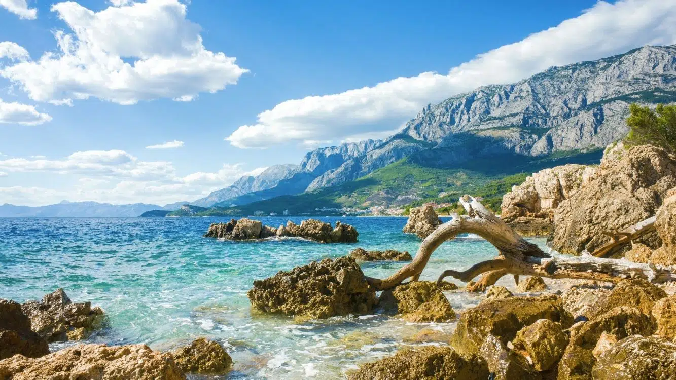
What does the Croatian coast look like?
The Croatian coast is the result of complex geological and tectonic processes, especially the subduction of Africa under the Eurasian tectonic plate - the collision of two continental masses. The Adriatic sea lies on the Adriatic microplate, which separated from the African Plate in the Mesozoic. The separation began during the Middle and Late Triassic when limestone deposition also began. Between the Noric and Upper Cretaceous stages, a series of carbonate sediments (dolomite and limestone) almost 8 kilometers deep was formed and created the so-called Adriatic carbonate platform.
The Croatian coast is very different from the western Italian coast, which is lower and sandy-muddy. The remains of this platform can be found in the Adriatic Sea and the surrounding young folded mountains (the Southern Alps and Dinarides).
What is the Croatian coastline type?
The Croatian coastline type is known worldwide as the Dalmatian coast. The Dalmatian type of coast is characterized by elongated islands, canals, bays, and peninsulas that extend parallel to the coast and larger relief forms. This geographical term for this type of coast is named after the coast of central Dalmatia in Croatia.
It is a type of indented coast where the main elements of the relief and structure of the island extend parallel to those on the mainland. The islands extend parallel to the coast, and the structure and relief of the coast and the islands coincide. The Dalmatian type of coast is formed when the landscape of parallel mountain ridges and valleys sinks when the level of the postglacial sea rises, so the valleys become canals and elongated bays, and the higher parts become islands. This type of coast is very rare.
What climate does the Croatian Adriatic coast have?
The Croatian coast, apart from its extreme northern and northwestern parts, has a Mediterranean climate with dry hot summers and a humid autumn-winter period. The highest parts of the islands of Brač and Hvar have a Mediterranean climate with dry warm summers. The northern and northeastern parts of the Adriatic, the coast of Istria, the Kvarner coast with islands, and the Velebit coast, have a moderately warm humid climate with hot summers. The interior of Istria has a moderately warm humid climate with warm summers.

- Csa - Mediterranean climate with hot summer
- Csb - Mediterranean climate with warm summer
- Cfa - moderate warm humid climate with hot summer
- Cfb - moderately warm humid climate with warm summer
- Df - humid boreal climate
What are the air temperature values on the Croatian coast?
The highest temperature values are in July and August, and the lowest temperatures are in January and February. Average January temperatures are the lowest in the northern Adriatic (e.g. in Rovinj at 5 ° C), and rise towards the south (e.g. in Dubrovnik at 9 ° C). Average July temperatures also rise from the northern (e.g. in Rovinj at 22.7 ° C) to the southern Adriatic (e.g. in Dubrovnik at 24.6 ° C). Also, the air in the coastal zone is colder than the air above the sea. Eg the average January temperature for Rijeka is 5 ° C, while for Mali Lošinj 7 ° C.
What are the sea temperature values on the Croatian coast?
Minimal sea temperatures in February or March are around 11 ° C. The maximum sea temperature in August is about 24 ° C. During the winter months, the temperature in the northern Adriatic is 3 ° C lower than in the south. The cause is warmer seawater flowing from the Mediterranean. Towards an open sea of values, sea temperatures rise during the winter, while in the summer, they are equalized.
How sunny is the Croatian coast?
The average number of sunny days varies significantly by season. In terms of months, the actual insolation in December is 3 to 4 hours a day (or 33% to 42% possible). In July, actual insolation is 9 to 11.5 hours (or 60% up to 75% possible). In the spring the increase in insolation is slowed down because of the passage of cyclones clouds across the Adriatic.
Croatian islands stand out for their large number of sunny hours during the year.
The sunniest place on The Adriatic:
- Hvar with 2,715 hours of sunshine
- Split (2,697)
- Dubrovnik (2,484)
- Vela Luka (2,671)
- Rab (2,479)
- Mali Lošinj (2,448)
- Rijeka (2,120)
If we compare the values of actual insolation on the Adriatic with other geographical regions of the Mediterranean, the Cote d'Azur has similar values as the Adriatic. Sicily, Greece, and Spain have 200 hours more.
How many islands are off the coast of Croatia?
Croatia is the land of a thousand islands. There are 1233 islands, islets, cliffs, and reefs in the Adriatic Sea. The Croatian part of the Adriatic coast has 1185 (96%) of them. 718 of the 1185 islands, islets, cliffs, and reefs are islands, and 66 are inhabited.
The 10 largest islands are:
- Cres (405.78 km²)
- Krk (405.2 km²)
- Brac (394.57 km²)
- Hvar (299.66 km²)
- Pag (284.56 km)
- Korcula (276.03 km²)
- Dugi otok (114.44 km²)
- Mljet (100.41 km²)
- Vis (90.84 km²)
- Rab (90.26 km²)
The island with the highest altitude is Brač, with Vidova Gora 780 m high, followed by Cres (639 m) and Hvar (628 m). The longest coasts are
- Pag (269.2 km)
- Hvar (254.2 km)
- Cres (247.7 km).
What counties are on the coast?
Croatia has 7 counties on the Adriatic seacoast:
Istra County - The coast of Istria is continuously indented, with small coves and harbors. There are no larger islands along this coast. Out of the smaller ones, the Brijuni islands are notable. Larger bays are Savudrija Bay, Antenal (mouth of the river Mirna), Lim Channel, Pomer, and bays around Pula. The eastern coast of Istria is predominately steep and difficult to access with several deeper cut bays and canals (Raška canal, Duga Luka, Maslenica - Rabac, and Plomin Channel)
Primorje-Gorski Kotar County - The continental coastal part of the Primorje-Gorski Kotar county is dominated by the Kvarner Bay with the port of Rijeka, the largest Croatian port. The larger bay in that part is Bakar Bay. The larger islands are Krk, Cres, Lošinj, and Rab. These islands are rich in small bays and beaches. Larger bays on the islands are Punat on Krk and Valun Bay on Cres.
Lika-Senj County - A steep coast following Velebit mountain with several smaller bays mark this county. The northern part of the large Pag island with the Stara Novalja bay belongs to this county.
Zadar County - The Zadar aquatory is rich in islands and islets. They are arranged in parallel rows, very close to each other, and connected by narrow passages. The coast is pebble coast, but also occasionally sandy. The coast indentation is substantial in the sub-Velebit area. Especially in the area of the mouth of the Zrmanja River, the Novigrad and Karin Seas, and the Ljubac and Nin Bays. The Islands of Pag and Dugi otok are littered with numerous bays. The cliffs along the outer coast of Dugi otok are a well-known geomorphological and geological landmark. The Kornati islands, characterized by elongated, smaller islets and cliffs, offer a unique atmosphere for boaters.
Šibenik-Knin County - Port of Šibenik and Lake Prokljan of the river Krka are high examples of a high degree of indentation. Larger bays on the mainland coast are Rogoznica and Morinj bays. There are no large islands in Šibenik-Knin County. There are several smaller islands in the northern part of the county. The island of Murter is connected to the mainland by a narrow canal.
Split-Dalmatia County - A sloping coast defines the continental coast of Split-Dalmatia County. The distinctly indented part is from Trogir Bay to Kaštela Bay. The coast under the foot of the mountain of Biokovo is steep. It is significantly indented near the town of Omis, the mouth of the river Cetina, and the town of Makarska. Makarska Riviera is famous for its long pebble beaches. The waters of Split-Dalmatia County are mostly larger islands. The most important bays on the islands are Nečujam on Šolta, Milna and Povlja on Brač, Stari Grad on Hvar and Viška vala on Vis.
Dubrovnik-Neretva County - The Dubrovnik coastal area is split into two parts by a small coastal strip belonging to Bosnia and Herzegovina near the town of Neum. The northern coast is flatter. Here we find the delta of the river Neretva with the port of Ploče. South of Neum and north of Ston is the Mali Ston Bay, connected to the Peljesac peninsula. Of the larger bays on Pelješac is Lovište in the northern part and the Ston Channel in the south. The Dubrovnik coast continues to the Pelješac peninsula with the bays Slano, Zaton, Rijeka Dubrovačka, Gruž and Župa bay. To the south, the coast is sharp with prominent Konavle cliffs. The extreme south of Croatia ends at Cape Oštra (Prevlaka) at the entrance to the Bay of Kotor in Montenegro. Northwest of Dubrovnik is the smaller Elaphite Islands. The larger islands are Korcula, Mljet, and Lastovo. Larger bays on the islands are Vela Luka, Lumbarda, and Korčula on the island of Korčula; and smaller bays: Pomena, Polače, and Sobra on Mljet, and Skrivena Luka, Velo Lago, and Malo Lago on Lastovo. Mljet Islands' Great Lake, with an islet connected to the sea by a narrow canal, is a popular attraction.
What are Croatian coastal cities?
Croatia has 128 cities. There are 42 of them on the coast.
The Croatian Adriatic coastal cities are listed below.
- Novalja
- Senj
- Umag
- Novigrad
- Poreč
- Labin
- Rovinj
- Pula
- Pazin
- Cres
- Mali Lošinj
- Krk
- Opatija
- Rab
- Kraljevica
- Crikvenica
- Novi Vinodolski
- Bakar
- Rijeka
- Pag
- Nin
- Biograd na Moru
- Zadar
- Skradin
- Vodice
- Šibenik
- Komiža
- Vis
- Stari Grad
- Hvar
- Supetar
- Omiš
- Makarska
- Sinj
- Trogir
- Kaštela
- Solin
- Split
- Opuzen
- Ploče
- Korčula
- Dubrovnik
Is Croatia on the Dalmatian coast?
Yes, a part of Croatia is the Dalmatian coast. Dalmatia is a geographical and historical region in southern Croatia. As a geographical region, it is also called the Southern Croatian Littoral. It covers the area of four counties (Zadar - without Lika, Šibenik-Knin, Split-Dalmatia, and Dubrovnik-Neretva) with a total area of about 11,960 km² and about 850,000 inhabitants. The region stretches for about 400 km along the Adriatic Sea and up to 70 km inland. It's one of the popular tourist destinations.
What is the Croatia coastline meme?
Croatia-Bosnia Border Map Meme depicts a map showing the border between two countries: Croatia and Bosnia & Herzegovina. The map demonstrates how a long stretch of Croatia's Adriatic Sea coastline territory blocks nearly all of Bosnia's access to the sea. In parodies about the map, Croatia was portrayed as spitefully blocking beach access.
In fact Bosnia and Herzegovina does have a beach. It is the second shortest coastline in the world after Monaco, with only 20 km in length. Neum strip actually pierces the long Croatian coast, cutting off its southernmost territory from the rest of Croatia. This has been bridged over in 2022 with the Pelješac bridge.
Neum was a port developed during the 18th century on the corridor between the Venetian and Dubrovnik Republic, which was established by the peace in Srijemski Karlovci in 1699, and then left to the Ottoman Empire. Neum remained part of that empire until 1878, when it belonged to the Austro-Hungarian Monarchy, which, despite its formal Ottoman rule sovereignty joined the Makarska district of the Kingdom of Dalmatia. During the war in BiH (1992-95), the Neum area was controlled by Croatian forces (until 1993 in alliance with Bosniaks). According to the Dayton Agreement (1995), it is part of the Federation of BiH.